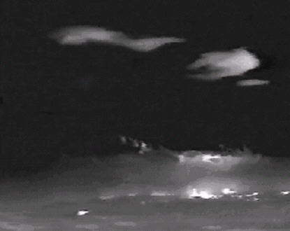
While air observers should note the material below for Field Observers, they should also recognise the potential for FLIR sensors to detect wind waves affecting fires. In the image above Looking to Thredbo from Yaouk, the heat from the fires is detected (white) three times: the lower glow is direct radiated heat from the fires; the middle glow is heat reflected off the smoke plumes, which include pyro-Cu clouds; and the upper glow is heat reflected off ice crystals in high-level lenticularis clouds. These clouds are in the crest of wind waves genertaed by the alps, and can be associated with extreme fire behaviour underneath.
Field Observer
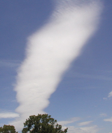
This photo shows a characteristic lenticularis cloud (“lenny” or Standing Altocumulus lenticularis). This cloud is aligned generally across the prevailling wind direction, but parallel with the escarpment, somewhere upwind, that generated the wind wave. There may be other parallel lennies in the area, typically at 15km spacing downwind. Air moving into the wind wave crest is cooling and forms cloud, while air decending out of the crest is warming and losing cloud. Thus while the cloud elements may be moving rapidly, the cloud itself is stationary. This is diagnostic.
Situation Unit Officer
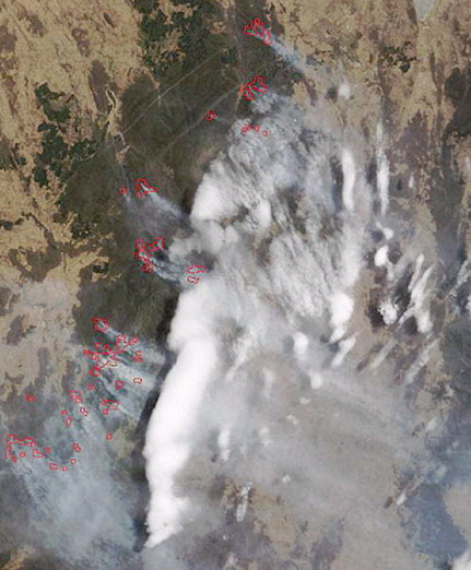
This satellite image shows a field of lennies generated in a NNW air flow by the escarpment on the western edge of the high country between Tumut and Khancoban. The rounded shape of the main upwind lenticularis is diagnostic.
Note the extended shadows.
Care must be taken when interpreting shadows in cross-path scanning satellite imagery. Sideways viewing angles will distort shadows in a way that cannot be remedied during rectification. Also visible here are commercial aircrafts’ contrails, which can be used to calibrate shadow analysis. They typically fly at around 10km ASL, but this can equate to as little as 8km AGL over the alps.
Imagery will often show lenticularis fields extending downwind for around 100km, and they typically span the rugged landscape.